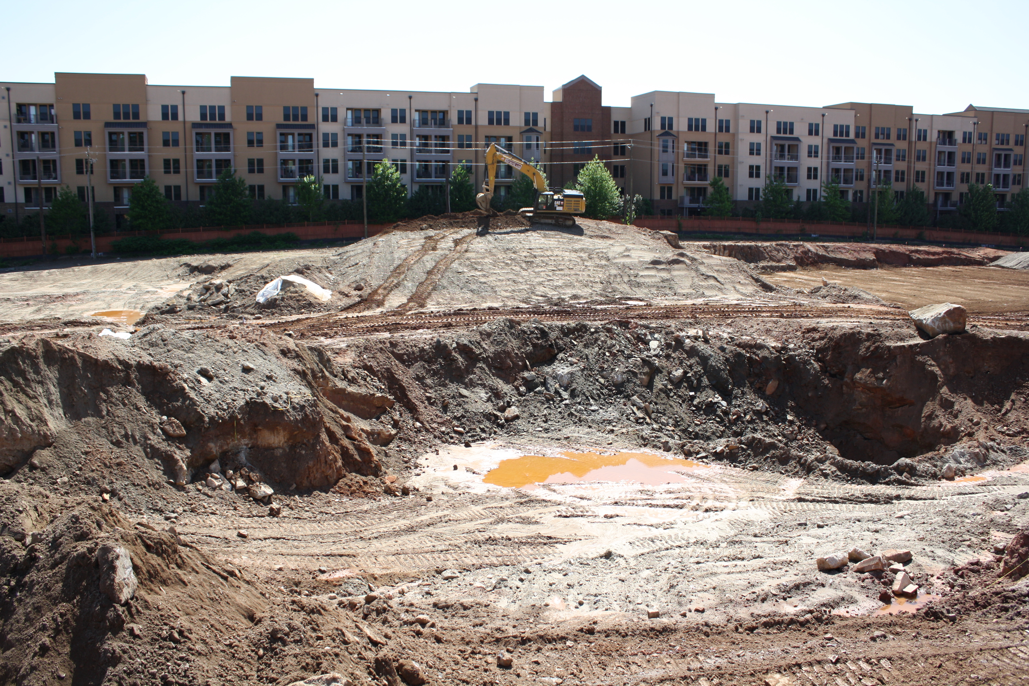
This former 22-acre industrial site was under development for residential and retail space when high levels of lead were discovered in one of the excavations. An environmental consulting firm was monitoring the on-site excavations and was routinely sampling at varying depths. Upon discovered of highly contaminated levels of soil, KEMRON was contacted and met with the environmental consultant, the general contractor and developer to discuss remediation options. Due to the very tight construction schedule, the primary concern was working closely with general contractor to not hinder progress if at all possible.
To expedite the process, KEMRON personnel immediately collected soil samples from previously identified stockpiles with known high concentrations of lead and delivered them to KEMRON’s in-house treatability lab. KEMRON’s lab conducted a treatability study for stabilization of soils with reagents. The treatability study was conducted over three days and was proven successful in binding the lead to achieve TCLP levels below 1ppm ml/kg. KEMRON developed a work plan that involved excavating contaminated soil from the source, blending the stabilization agent in the soil, and arranging transportation and disposal of the treated soil to a Sub-title D landfill. Due to time constraints, the work was scheduled to begin the following week. KEMRON’s safety manager developed a site specific safety plan and an air monitoring program for the site.
KEMRON mobilized the following week and began soil excavation while awaiting landfill approvals. Excavated soil was placed in a staging area in preparation for mixing with the stabilization agent. The stabilization agent was delivered in one ton supersacks and mixed into the soil at a 2.5% to 3% dosage. The treated soil was stockpiled in 500 ton piles and sampled for treatment confirmation.
Initially, KEMRON was asked to base the scope of work on an estimated volume of 1000 tons. Within a few days, it was became apparent that the extent of the contamination was much more widespread than originally thought. KEMRON met with the stakeholders and proposed a plan to ramp up the production to keep the project on schedule. Larger and additional equipment was brought on site so that excavation, treatment and truck loading could continue simultaneously throughout the day. Eventually, KEMRON treated and disposed of more than 20,000 tons of contaminated soil. KEMRON was recognized by the general contractor as being a key factor in keeping the project on schedule.
The former National Smelting and Refining Site consists of approximately 3 acres located near midtown Atlanta in an area known for its heavy industrial operations over the last century. The site was home to a secondary lead smelting facility that processed lead-acid batteries and lead-bearing scrap that operated from 1914 until 1984 when the facility went inactive. The site remained inactive and in disrepair until a site investigation conducted by the EPA in 1999 incited a Release Notification. In 2001 the US EPA released an Administrative Order of Consent demanding additional subsurface soil, sediment, and groundwater sampling and analysis for contaminants of concern (COCs) by the identified responsible parties.
In 2005-2006 a prospective purchaser became interested in redeveloping the property as a possible mid-to high-rise mixed-use development under the Georgia Brownfields Redevelopment Program. As consultant for the prospective purchaser, KEMRON supplemented former assessment activities at the site by conducting systematic surface and subsurface sampling of soil to accurately define volumes and extents of contaminated media. The assessment activities performed by KEMRON determined that soil at the site was extensively affected by releases from secondary smelting operations and burial of metal-containing materials. Petroleum affected groundwater and soil were present in the area of the former underground tanks on the southeast part of the property. The main Chemicals of Concern (COCs) detected at the site were metals, but VOCs, PCBs, and PAHs were also detected at notification
concentrations.
Impacted soils span the subject site and extend into the water table at approximately 10 ft below ground surface (bgs) in various locations. During delineation activities a solid lead core was encountered at approximately 7 ft bgs in the north central portion of the site. Slag material was also encountered in the property’s southwestern quadrant and north central portion. The distribution of lead impacted soil is somewhat erratic and impact concentrations do not convey vertical trends. Due to the sporadic nature of the lead impacted soils, it was determined that segregating soils and spot digging “problem areas” would not be effective during a removal action. The erratic vertical and horizontal distribution of lead contamination across the site and extremely high concentrations known to be located at 10 ft below ground surface (bgs) would require a site-wide removal action to at least 10 ft bgs for the purpose of remediating the majority of the site to applicable remediation goals. Various areas could require removal to 15 ft bgs or more. The total estimated weight of material for removal and disposal in a Subtitle D and/or Subtitle C could be as much as 82,000 tons. This amount of soil removal and disposal would
ultimately make the cost of conducting a full scale removal action not financially feasible in that it would
significantly exceed the market value of the property.
The potential high cost of remediating this property has kept it unappealing to investors for over 20 years and could cause the property to remain an unusable eyesore; even as the surrounding properties are redeveloped into economically viable communities (Atlantic Station is adjacent to the property). As an alternative to a continued struggle between the regulatory agencies and identified responsible parties that has the potential to drag out for years, the prospective purchaser has offered to work with the US EPA and the GA EPD to redevelop the property under the Georgia Brownfields Redevelopment Program. The redevelopment will be designed to contribute to economic stimulus in the area through the addition of commercial and retail space producing a higher and better use of the subject property. While initiating this effort KEMRON is working closely with the US EPA and the GA EPD to produce alternative cleanup goals (Type 5 Risk Reduction Standards (RRSs)) for the site soils and groundwater that will allow for soil engineering controls and groundwater limitation of liability as an alternative to the substantial and costly soil excavation and disposal. The GA EPD agrees with this remedial approach and has approved a corrective action plan for the prospective purchaser. KEMRON and the prospective purchaser are moving forward with finalizing the remedial design and implementation plan. KEMRON will work closely with the building designers and construction contractors to ensure that any use of site after remediation activities are completed will preserve the integrity and effectiveness of the engineering controls.
KEMRON was retained by the property owner to complete a 27-acre cap and 5-acre wetland creation project for a large scale Brownfields redevelopment project located on the Raritan River in Sayreville, New Jersey. This project was conducted as the first phase of a 480-acre mixed use redevelopment project. The specific Remedial Action Objective (RAO) for the site was to cap soils which contained concentrations of constituents of concerns that exceeded residential soil cleanup standards.
KEMRON began preparation of this capping and wetland construction project by establishing field support facilities including field offices, material storage areas and the construction of all project haul routes. KEMRON was also responsible for obtaining special traffic permitting for vehicular traffic to and from the site. Concurrently with this activity, KEMRON completed the clearing and chipping of vegetation in the disturbed total wetland impacted area. The trees will were chipped and used onsite for erosion control. Some tree root balls were incorporated into the overall wetland design as instructed by the on-site wetland design engineer. Once the areas were cleared an existing topographic survey was completed in order to determine the zero balance cut and fill volumes available and the resulting elevations prior to the cap construction. Water management systems were installed and kept in continuous operation as required to keep the cut and fill zones dry during construction.
Following site preparation activities, KEMRON established grade control for the site and began excavation of the wetland areas while placing the material as backfill in order to meet design grades within available cut quantities of approximately 37,000 cubic yards. All soils will were placed and compacted in lifts creating the cap sub grade. Following placement and compaction of the wetland cap sub grade soils, KEMRON began the placement of the cap material to include importing approximately68,000 cubic yards of clean common fill. Upon placement of the 85,000 cubic yards (18-inch depth) of clean fill, KEMRON imported and placed 40,000 cubic yards of topsoil (6-inch depth). This total capped area is approximately 27 acres inclusive of the final wetland area of 5.7 acres.